Wednesday, June 26, 2013

Arrival in Florida

Wednesday June 26th (Day 302)


This is the Wanee Lake Golf and RV campground we left in Georgia. We drove down I-75 to Florida...I guess we were anxious to get to our final destination and to leave the famous Southern Georgia gnats that were annoying us like crazy! The trees in Georgia seemed to be all pines and hardwoods...lots of green fields...some of which were peanut farms.


 We know that there's lots of Spanish moss on trees in other states, but it seemed to us that as soon as we crossed into Florida we saw it all over all the trees. The temperatures rose even more as we drove south, hitting 94 as we arrived at our park. We are in a place called North Ocala RV park, which is about halfway between Gainesville and Ocala. We're about 25 miles from Kyle and Serenity's.


Looking out at what is on our awning side. Lots of shade and Spanish moss.


 We parked, plugged in the AC, and cooled off a bit before we planned to hit the pool. Unfortunately, as we waited, the thunder started up, and now we're waiting out a rain storm......but it is at least cooling off a bit AND THE GNATS ARE GONE!!.

Behind us is the crowd of neighbors.


Total miles driven today=195

Tuesday, June 25, 2013

Stopping in Georgia

Tuesday June 25th (Day 301)


We left Leesburg and headed toward Florida via Georgia. We were just tooling along a highway, when we suddenly saw a sign for Andersonville National historic site. So, we turned around and rerouted our tom-tom to take us through the park.
Andersonville was a notorious prisoner of war camp run by the Confederates during the Civil War. Now, it also houses a museum that is a memorial to all American prisoners of war, from every era.
This is the outside of the visitor center/museum. We think it was designed to look like a prison itself.


The museum was interesting, with all sorts of exhibits. Some were heartening, and others were very hard to look at. A common theme was that POW's often looked for ways to find hope whether through denial, creativity, or planning an escape.

This was a sign welcoming some POW's home.


There was a driving tour, of course, around the perimeter of the original camp. Various states have put up memorials around the grounds.


This section of the stockade wall has been reconstructed to show what the original looked like.


We couldn't spend a lot of time there because it was almost closing time...we lost another hour when we crossed into Georgia. So, we drove on to our destination for the night, Wanee Lake golf and RV resort in Ashburn, Georgia. The resort is about 4 miles outside the town. As we were driving through the town, we saw signs for "Keith - A - Que"...so in honor of our son, Keith, we had to stop and check it out. It's a barbeque place and we bought a small pork sandwich just to try it. Harris thought it was OK. Judy decided one bite was enough for her.


Total miles driven today = 276


Monday, June 24, 2013

300th day in Howie!

Monday, June 24, 2013 (Day 300)

Another lazy day in Leesburg, Alabama

We're only about 400 miles from Gainesville, Florida, and there is no hurry yet to get there, so we decided to stay another day here. We went to a town about 20 miles away to do some geocaching, and to check out a "real Southern restaurant" that features fried catfish, and fried everything else. Unfortunately, (or maybe fortunately) the restaurant was closed until dinner time. We had planned on eating a late lunch there, but didn't want to hang around for dinner. So, our arteries were saved.


The first geocache Harris found today, called "hanging around." He looked at everything that could be above his head, and then finally looked down and saw it hanging in a grate.


The next one was under a lamp post skirt...easy find...but fun name and container...called "skullduggery".


 This one was a first for us...it looked like a wad of chewed up bubblegum under a picnic table. Luckily it was a plastic replica!


 Harris had seen this type of cache before, so he knew what to do. You have to get some water (from the river below) and pour it into the tube to make the cache container bob to the top.


 When we returned to our camp, we found it was almost empty of campers. Most have gone home for the work week. There were, however, many, many geese taking over the empty campsites and enjoying a swim in the lake. Many geese. Many, many geese.... and geese poop.


Miles driven today = 40

Sunday, June 23, 2013

Leesburg, AL- A great place to spend a birthday

Sat. and Sunday  6/22-6/23 (Days 298 & 299)


 We left Tennessee and drove a fairly short day (about 220 miles) to Leesburg, Alabama. We picked this place because it has a pool....which is great on these hot, hot days. (Cedar Point Campground)

This is a picture of our campsite beside the lake. This campground is a lot fuller than the last one...especially here on the weekend. As we've talked to people, it seems a lot of locals come here for the weekend, leaving big RV's here for a month or more.


 People like to swim in the lake, but we passed and used the pool instead.


 Early morning duck family taking a stroll around the neighborhood.


 Sunday morning we went for a "geocaching walk" along this path. There were about 10 caches here.


 Harris says "Howie always takes the high road!"


 We came back for lunch, then headed out for  a real geocaching spree. We had met a fellow cacher on the last stretch, who told us about this area, and gave us some help. We ended up getting over 40 caches...they were spaced out about every half mile or so, so it was easy to get a lot in a fairly short amount of time.
Harris officially becomes a "geezer" today...and he can't wait to get a lifetime national park  pass! Happy Birthday!


Total miles driven today = 255

Saturday, June 22, 2013

Two Days in Teneessee

Thurs. and Friday 6/20-6/21 (Days 296 & 297)

We got up and out early (for us)...early enough that the morning mists were still hanging around the roads as we left Arkansas. Harris asked our little tom-tom (navigator) to take us on the back roads again. So, we were back to the roller coaster, up and down, around and around as we wended our way out of the Ozarks.


 We enjoyed driving along the ridges of the Ozarks dipping down and climbing up the next.


 We had been camping by the Buffalo River, which is also in a National Forest. There are many, many outfitters like this one all along the highways, although most don't have a limo!


"Established in 1972, Buffalo National River flows freely for 135 miles and is one of the few remaining undammed rivers in the lower 48 states. Journey from running rapids to quiet pools while surrounded by massive bluffs as you cruise through the Ozark Mountains down to the White River".


 We've also noticed the kudzu absolutely taking over the trees and forests.
 We left Arkansas, dropped briefly into Mississippi, then entered Tennessee outside of Memphis. Culture shock again as we went on the interstate and ground to a halt for construction and then again for a semi that had lost part of its load of fiberglass panels. Traffic was terrible! We finally went off on a smaller freeway, to a smaller highway....to a smaller road.....then our little navigator took us down a dirt road....we kept thinking, "this can't be right, but we'll follow it anyway". Famous last words. Tom-Tom was not taking us to our next campsite via the same directions that were in the book, but, hey, he might know a short cut, right? We had to laugh when the familiar words were spoken, "You have reached your destination".
We were on a dirt road in the middle of a forest. No habitation in sight anywhere. Boy, were we glad it was afternoon, and not the middle of the night!
We kept going, and eventually found ourselves on the back side of a fence, which we followed around to...an actual paved road...and..an entrance to a camp! Yay!

 Cherokee Landing  (outside Saulsbury  and Middleton ) is a huge place. It has over 300 RV sites, cabins, a lodge and a large swimming pool. (which is why we came here). We had to wait at the locked gate for someone to come and let us in. She told us we could choose any site we wanted. So, we drove through the campground, looking for a good spot. What makes a good spot, you might ask?
One close to the bathroom and showers? nope.One close to the swimming pool? nope. We tried 3 different places before Harris chose this one. Can you guess why it was the spot? No,nothing in the picture would give you a clue. It was the closest to the lodge and gave us weak but useable wi-fi. Priorities!


 We set up camp, had an early dinner and went swimming to cool off. The next morning we got up early for a walk through the complex before the day got too hot. The lodge overlooks a small lake.


 After breakfast, Harris decided he'd like to geocache in the area. Well, as long as we were driving, Judy decided she'd like to see the Shenandoah National Military Park about 45 miles away. So, we did both. Harris found 7 caches, and then we went to the battlefield park. Grant and Johnston fought a battle here on April 6 and 7, 1862. Grant won because he had reinforcements that came to his aid on the second day. Johnston was killed in the battle, which also contributed to the Confederate defeat.


 The visitor center


 Looking over the brochure for the directions for the driving tour.


 canons


 More cannons...they were everywhere!


 After the tour, it was back to the campground for dinner, swimming and cards. This place is very, very quiet, in part because it's in a forested area, full of birds and deer. Also, because of the 300+ sites available, only about 15 are occupied. It's a big, empty place! We could picture it in its glory days with 600+ every summer weekend.


Total miles driven today=95

Wednesday, June 19, 2013

Our short stay in the Ozarks

Tues. & Wed. 6/18-6/19 (Days 294 & 295)


We drove on Tuesday, leaving Kansas behind and cutting through a bit of Missouri. Still lots of trees..and blue skies...the temperatures are climbing, hitting 90!


As we headed into Arkansas from Missouri, we drove into the Ozark forests and "mountains". (the highest point in Arkansas is 2753 ft) But the road was a little like a roller coaster...up and up..down and down...lots of curves.


After the plains of Nebraska and Kansas, these rock walls were interesting to us, so we took some pictures.


We ended up outside a little town called Jasper. Our park is called Dogwood Springs Campground. It is a small family run park, with all the sites carved out of the hills to get level spots. Everything around here is on hillsides--homes, farms, towns, etc. It's getting hot and sticky for us Northwesterners, so we were glad to find a park with a pool. Harris took this picture after we spent the afternoon there. (We're not in there anymore). Can you spot Howie through the trees?
Wednesday was a day to stay and relax, and not drive anywhere!


Tomorrow we head into Tennessee to get closer to our holding point so we can make a last mad dash when the call comes that the baby has arrived. We'll definitely have to come back here and spend more time exploring.


Total miles driven = 313

Monday, June 17, 2013

chore day in Kansas

Monday 6/17 (Day 293)


Fields of corn...acres of corn...miles and miles of corn....guess we're in Kansas!


We drove a lot today, with very little stopping, except for construction work. We ended up here in Lyndon, KS, a little ways from Topeka. This has been a "chore" day. Because we got here in the afternoon, Judy was able to do laundry and Harris was able to put a new valve gate for the black water on Howie. Just like home...always something to fix!
We're stopped for the night at Crossroads RV Park...seems like a nice, quiet place about 30 miles south of Topeka. Very little traffic out here. We'll be able to see stars tonight instead of thunderclouds, and hear crickets instead of trains. Yay!


 (A side note since there wasn't much to write about today.) We've gone just over 2000 miles with very little on the interstate. Our gas mileage has averaged almost 26 mpg with the highest 26.5  around Yellowstone (all the 45 mph limits). This also includes the tail wind when traveling west to east and the gradual descent onto the midwest plains. For sure this will be very different when returning.

Total miles driven today = 305

Sunday, June 16, 2013

Tornado watch in Elm Creek, NE

Sunday  6/16 (Day 292)

Before we left Wyoming, Harris took a picture of our next door neighbor's hobby. He is a contractor by trade, and loves to work on this little log cabin when he's camping. He's been working on it for three camping trips and it's made out of one piece of wood. It has a stone fireplace inside with a miniature rifle that will go above it. He made a table and chair to go inside as well. It's a real work of art.


Oops! Out of sequence....a great sunset shot of the park in Wyoming.


Harris found this robin's nest in the morning....three little birds, all waiting to be fed. It is Father's day...and it reminded him of our own chicks when they were little!


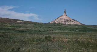
We made one stop on our way through Nebraska...Chimney Rock, where emigrants on the Oregon trail often stopped to camp by the river and regroup. This landmark told them they were one-third of the way west.


The visitor's center had a small museum inside. One display had this poster, and items for kids to put into a wagon. It weighed the items and told you if you over your limit, and asked you to compare your load with this list.


Boy, this daily routine would kill us!


Coming through western Nebraska, we saw many, many coal trains heading east. We were also struck by how many trees we saw as well. But then we remembered that Nebraska started Arbor Day in 1872. They've had a lot of years to plant these trees!


The sky got darker and darker as we headed east...at one point the whole sky was black...all around us in every direction.


We finally reached our little resting spot at Elm Creek, called Sunny Meadows. It isn't sunny, and there are no meadows. It's just a small RV park off the interstate. As we were settling in, Harris's phone suddenly chirped with a severe weather warning...tornado warning...take cover...then the sirens started. We asked someone where we should go. We were told, "the women's bathroom" and so we headed that way. About 10 people joined us (with 3 dogs) and we watched the rain and hail pour down. We waited until the sky cleared up somewhat, and then dodged the huge raindrops as best we could as we ran back to Howie. No tornado, thank you God. There is still plenty of lightning and thunder and rain going on, but we think the tornado danger has moved on. It sure seems like every time we cross Nebraska we run into this pattern somewhere!


At around 9PM the tornado watch was called off and the sun made its appearance if only to take a bow before sinking for another night's rest (Notice the rain drops in the foreground).


Total miles driven today = 312

Saturday, June 15, 2013

Fort Laramie, WY Fur Rendezvous

Saturday  6/15 (Day 291)
Happy 38th anniversary! 

We decided to stick around today and see the fur rendezvous re-enactment and Fort Laramie. On our way there, we had to stop and do a little geocaching, of course. Our first one was a magnetic cache at this statue which became the official symbol of Wyoming.


Our second was at this bridge. It was built in 1875 and is an historical landmark now.


(info taken from the official brochure of Fort Laramie)
Fort Laramie was first built in 1834 near the confluence of the Laramie and North Platte rivers. (First named fort William, then John, and officially named Laramie in 1849). It was first a trading post between Indians and trappers. Then it became an important stop for the emigrant trains on their way to Oregon, California or Utah. It became a military post in 1849, and soon became the principal military outpost on the Northern Plains. The fort was also the primary hub for transportation and communication through the central Rocky Mountain region as emigrant trails, stage lines, the Pony Express, and the transcontinental telegraph all passed through the post. Fort Laramie played an important role as host to several treaty negotiations with Northern Plains Indian Nations. When the Indian wars ended, its importance diminished and the fort was abandoned in 1874. Some buildings have been restored, and others are just the foundations.


At the campground outside the fort, different characters told us a lot about the fur trading days. This man was a "free" trapper, meaning he worked for himself and not a company. He told us all about each piece of equipment he carried.

 These 2 guys gave talks about the various rifles and pistols of the period.

One woman, dressed as an Indian, explaining her weaving and dye methods.


 These guys are discussing the various types of saddles (cost between 7-14 dollars back then).


This man was a trader and is demonstrating a neat trick with the tobacco tin. You could keep the tobacco in the tin, then, use the magnifying glass on top to get the sun to light your pipe.


Another shot of the trapper who talked about spreading pelts, lead, clothing, and everything else in 200 pound units for the horses and mules.


and his camp.


Here are trade goods spread out for display by an independent trader. These traders tried to sell goods to people before they made it to the fort to trade.


This woman was at the fort itself, demonstrating her crochet. She reminded Judy of the quilt figure "Sunbonnet Sue". Her bonnet completely hid her face.


Barracks at the fort.


Harris just liked this tree...shade is great on a hot day like today!

Harris took this shot, trying to demonstrate how large the fort grounds were. Like most midwest forts, there was no wall due to a lack of funding. This probably led to much larger forts in terms of land area.


We came back to camp in the afternoon, just relaxing in the shade. Harris listened to the Mariners win and cooked a great steak dinner. 38 years! hard to believe.

Total miles driven today = 15